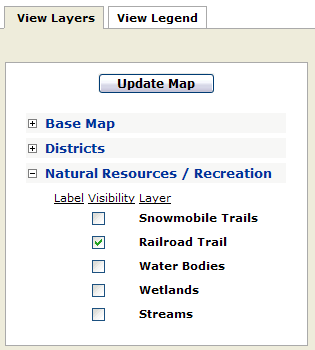
The View Layers window is used to toggle the visibility of map layers and associated labels 'on' or 'off' in the map window. Checking a layer 'on' means that the layer will be visible in the map window, with the exception of scale dependent map layers discussed below (*)
To toggle a map layer 'On':
1) Click on the View Layers tab.
2) Click on the box next to one or more map layers under the Visible column. A black check mark will appear in the box.
3) Click on the Update Map button to refresh the map and display your changes.
*NOTE: the aerial photos, as well as the labels for most layers, are scale dependent and will not be visible, even with turned 'on', until the map window is zoomed in to a small geographic area.
NOTE: By default one or more layers may be visible when the application runs for the first time.
To toggle a label visibility 'On':
1) For map layers that are toggled 'on', click on the box under the Label column. A black check mark will appear in the box.
2) Click on the Update Map button to refresh the map and display your changes.
NOTE:
When the features of
a map layer are turned off, the labels will automatically get turned off.
For labels to display, the features of the map layer must display also.
To toggle map layer visibility 'Off':
1) Click
once on the check box next to the map layer under the 'Visible' column
to remove the black check mark.
2) The map window will automatically update, and the layer will not be displayed.
NOTE:
When the features of a map layer are turned off, the labels will automatically get turned off.